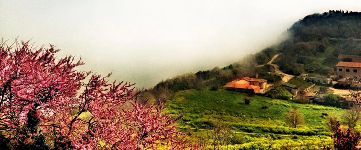
Catastrofi naturali e tragedie causate dagli uomini hanno fatto sì che il centro storico di Ancona venisse, più o meno consapevolmente, dimenticato da larga parte degli abitanti della città. Solo alcune persone nel corso del tempo, hanno mantenuto in qualche modo viva la memoria di questi luoghi, tra i quali il Parco del Cardeto.
La guerra ha aperto grandi vuoti nello spazio urbano, soprattutto nella zona del Guasco e delle aree circostanti. Talvolta si è scelto di lasciare tutto come 70 anni fa, altre volte si è scelto di ricostruire con discutibili risultati, sempre è mancato un progetto urbanistico unitario.
L’area che va dal colle Guasco, con la cattedrale di San Ciriaco, il Colle dei Cappuccini e il Monte Cardeto e oltre fino a via Panoramica, ha avuto una sorte segnata in positivo dall’essere soggetta, in larga parte, a servitù militari. Immediatamente ai piedi del Guasco troviamo la chiesa di San Sebastiano e San Gregorio Illuminatore. Il titolo di San Gregorio ci rimanda all’anno 1847, quando entrarono nella chiesa le Monache Benedettine Armene (San Gregorio Illuminatore è il santo patrono dell’Armenia). Ma la chiesa era legata già da secoli alla nazione Armena se nel 1570 il mercante armeno Giorgio Morato commissionò la Madonna con bambino e santi al pittore Girolamo Siciolante da Sermoneta che trovò posto nell’altare della chiesa di San Sebastiano e che nel 1811 fu asportato dai francesi per essere portato a Brera da dove, vista la mancanza di spazio, fu collocata nella sagrestia della chiesa di Calcinate in provincia di Bergamo dove ancora si trova… (questa è un’altra triste storia che accomuna tanti paesi delle Marche e dell’Umbria e di cui parleremo un’altra volta). Le Monache Armene rimasero nella chiesa fino al 1898. A lato della chiesa si estendeva il convento, che già nel 1835 iniziò la sua funzione carceraria. Dopo il sisma del 1972 e l’abbattimento dell’edificio, sono iniziati i lavori di scavo dell’anfiteatro romano. Oltre l’avvallamento costituito dall’Anfiteatro, si sale di nuovo, verso il Colle dei Cappuccini. E’ da questo punto che entriamo nell’area del Parco del Cardeto.
Tutta l’area di cui stiamo parlando è il luogo dove si sono avuti i primi insediamenti umani della città di Ancona. In particolare ai piedi del Colle dei Cappuccini, tra via dell’Ospizio e via del Faro si trovava un insediamento protovillanoviano (X-IX secolo a.C.) in seguito occupato da popolazioni Picene. Sulla sommità del Colle sorgeva la rocca di San Cataldo, iniziata dal Malatesta e completata dal Cardinale Albornoz, che gli anconetani distrussero nel gennaio del 1383. Nel 1554 in quell’area vennero costruiti la chiesa e il convento dei Cappuccini (dai quali il nome del Colle), in seguito divenuti la Caserma Stamura. L’Università Politecnica della Marche aveva mostrato un interesse per l’edificio a patto di poterlo raggiungere con una strada, ma lo scorso 25 novembre il Comune di Ancona con un atto di Giunta ha dato il nulla osta alla vendita della ex Caserma da parte dello Stato, attraverso la società Invimit Sgr. Oltre alla Caserma sul Colle si innalzano due fari: quello usato attualmente e il vecchio faro del 1859, nelle vicinanze del quale si trovano alcune batterie del periodo post-unitario. Per alcuni anni il vecchio Faro è stato tenuto aperto da Legambiente, ma da tempo è chiuso perché necessita di lavori di restauro.
 Tra il Colle dei Cappuccini e il Monte Cardeto si estende il Campo degli Ebrei, l’antico cimitero ebraico. Datano al 1428 i primi documenti relativi alla destinazione di questo luogo ad area cimiteriale per la fiorente comunità ebraica anconetana. In origine confinava con il campo della Mostra, l’attuale Piazza Malatesta, poi venne allargato nel 1462 e nel 1711 fino ad occupare lo spazio odierno. La parziale sistemazione dell’area ha permesso di localizzare, soprattutto nella parte più bassa, numerose lapidi, tra le quali alcune, le più recenti, in lingua italiana. Il muro ottocentesco che cinge il camposanto dal lato verso la città è stato restaurato e utilizzato come un marciaronda che sale fino al belvedere, a ridosso della porta che conduce al Faro, in modo da permettere una visione d’insieme del luogo. L’area cimiteriale è stata ridotta di circa 10 metri rispetto alla strada che sale a ridosso del mare. Nell’area a ridosso del muro lato città è cresciuto negli anni un boschetto di olmi che è stato mantenuto come pure molte delle essenze presenti nell’area del Parco. All’interno del Campo sono state ricollocate anche le poche lapidi che rimanevano sul ciglio della rupe e quelle molto più numerose (circa 70) che, rovinate a mare, sono state recuperate e per molti anni sono state depositate in un’area del cimitero ebraico alle Tavernelle. Alcune casermette presenti nelle adiacenze del Camposanto ebraico erano state trasformate nel cosiddetto Deposito del Tempo, ma la mancanza di cura e manutenzione le ha fatte ripiombare in una condizione di degrado. Dalla parte opposta di queste Casermette è giunto ormai alla fine il restauro della Polveriera Castelfidardo, a cui manca in sostanza solo l’arredamento della sala che dovrebbe essere stato affidato con una gara. Sempre nelle vicinanze si trova l’ex infermeria quadrupedi della caserma Villarey che è stata restaurata ed è utilizzata dalla Facoltà di Economia della Univpm di Ancona. L’area del Parco continua verso le fortificazioni settecentesche fino all’ingresso sud che si trova al di sopra dell’ex ospedale Umberto I. In questi anni la popolazione ha preso coscienza della bellezza e dell’importanza di questo luogo. Uno degli aspetti più affascinanti risiede proprio nella presenza di questo importante parco, insieme naturalistico, archeologico e storico, all’interno della città. E’ mancata però una continuità nel far vivere alla città e anche ai possibili turisti tutta questa bellezza.

{:}{:en}
Because of natural catastrophes and tragedies caused by men, the old town of Ancona has been – consciously or unconsciously – forgotten by most of the inhabitants of the city. Only a few people over the years have kept the memories of these places alive in some way.
The area that goes from the Guasco hill, with the Cathedral of San Ciriaco, the Colle dei Cappuccini and the Mount Cardeto and beyond to Via Panoramica, has been marked by a positive history, largely, because it was an area subject of military servitudes
Immediately at the foothill of Guasco there’s the church of San Sebastiano and Saint Gregory the Illuminator. The title of St. Gregory brings us back to the year 1847, when the Armenian Benedictine Nuns entered the church (St. Gregory the Illuminator is the patron saint of Armenia). The church was bound for centuries to the Armenian nation; in fact in 1570 the Armenian merchant Giorgio Morato commissioned the “Virgin with child and Saints” to the painter Girolamo Siciolante da Sermoneta, whose tomb found place in the altar of the church of San Sebastiano. In 1811 it was removed by the French and brought to Brera where, due to lack of space for his tomb, it was placed in the sacristy of the church of Calcinate in the province of Bergamo, where he still rests… (this is another sad story common to many villages in Le Marche and Umbria, we will talk about it in another post). The Armenian Nuns remained in the church until 1898. On the side of the church is the convent that was also used as prison since 1835. After the earthquake of 1972 and the demolition of the building, the excavations for the Roman amphitheater began. Above the valley of the Amphitheater, you can rise towards the Colle dei Cappuccini. It is from this point that we enter the area named the Park of Cardeto.
The area we are talking about is the area in the city of Ancona where the first human settlements took place. Particularly at the foot of the Colle dei Cappuccini, between Via dell’Ospizio and Via del Faro there was a Protovillanovian settlement (10th and 9th century Before Christ), later occupied by Picene populations. On the top of the hill there was the Fortress of San Cataldo, begun by Malatesta and completed by Cardinal Albornoz, later destroyed by the Anconitans in January 1383. In 1554 the church and convent of the Cappuccini (from which the name of the Colle) were built in that area, then later they became the military base Stamura. The Polytechnic University of Le Marche (UNIVPM) showed interest in the building, only if it was provided of a good road, but on Nov., 25 2014 the Municipality of Ancona with a municipal act gave the authorization to sell the former Military Base Stamura by the State, through the brokerage of the company Invimit Sgr. In addition to the Military Base there are two lighthouses upon the Colle: one is currently used, and an old lighthouse dating back to 1859. Close to the old lighthouse there are also artilleries from the post-unitarian period. For some years the old lighthouse was kept open by Legambiente, but lately it has long been closed because it needs restoration work.
Between the Colle dei Cappuccini and Mount Cardeto there’s the Campo degli Ebrei, the ancient Jewish cemetery. The first documents related to the destination of this area to a cemetery for the local flourishing Jewish Anconetan community date back to 1428. Its original borders were Campo della Mostra, today’s Malatesta Square, then later it was enlarged in 1462 and 1711 to cover today’s space. The partial renovation of the area allowed to identify, especially in the lower part, numerous tombstones, including some of the most recent, in Italian language. The nineteenth-century wall, that straddles the cemetery from the side towards the city, was restored and used as a military walkway that rises up to the Belvedere, close to the door that leads to the Lighthouse, so to have a panoramic view of the site. The cemetery area was reduced by about 10 meters from the road that rises close to the sea. A holm grove has grown over the years in the area close to the wall, on the side in front of the city, that has been preserved as well as many of the essences in the Park area. Inside the cemetery were also replaced the few gravestones that remained on the edge of the cliff and the much larger ones (about 70) that, ruined at sea, were recovered and for many years were deposited in an area of the Jewish cemetery at Tavernelle. Some barracks close to the Jewish cemetery were transformed into the so-called Warehouse of Time, but lack of care and maintenance made them fall back into a state of degradation. From the opposite side of these Barracks, the recently restored Polveriera Castelfidardo, which essentially lacks only the furnishing of the hall that undergoes a public tender notice. Nearby is the former quadruped infirmary of the military base Villarey which was restored and is used by the Economics Faculty of the UNIVPM of Ancona. The Park area covers also the eighteenth-century fortifications to the south entrance above the former Umberto I hospital. In these years the population has become aware of the beauty and importance of this place. One of the most fascinating aspects lies in the presence within the city of this important park for its naturalistic, archaeological and historical features. However, there is no continuity in making the citizens and potential tourists enjoy all this beauty.
{:}